Louisville Loop
Dave and I rode early at 7.00a.m. Sunday b/c I had a day full of family plans. He's been tri-training at 5.00 for a while now, so he's old hat to getting up earlier than necessary. My morning was further "enhanced" by having gotten in late from an excellent Times New Viking/Guided by Voices show, which I personally and unsatisfactorily bailed on earlier than needed. Blah. Age.
The plan was for a 36-miler or so in the 26F temps. Both of us realized relatively earlier that we had quite not pegged the temp requirements, especially for our feet. Ah, the feet again. We both were on single speeds, making for an easy roll until the hills in Iroquois and goofy littler rollers on Manslick. Once we crossed the tracks on the 2nd Manslick we happened upon what was for me a new site, a new parking lot next to Pond Creek and the big mound of rubble that's been there a while. An asphalt path rode into the distance, and so did we. You always have to be up for exploring, right? I assumed, and still do, that it's a newly-opened extension of the Louisville Loop (more on that at bottom).
Once on the trail it became very reminiscent of areas found both around Shawnee and parts of the Levee Trail around the Mill Creek LG&E plant. It nicely followed the creek bolstered by some obvious juvenile plantings. As with portions of the Shawnee Riverwalk, I think it's too close to the creek and will suffer flooding issues, but either right-of-ways or ignorance keep the LL folks from learning from past mistakes.
Below is a master planning map of the area we were in. If you were to follow the orange path from its northern most tip on this map above the letter "A-rea", that's where we found it. It continued a short portion west until the little hook around the subdivision above "STUDY". My complaint has always been that it's a recreational trail but doesn't go anywhere. How does it contribute to transportation infrastructure? Minneapolis and Portland, real bike towns, build bicycle highways that move people among significant residential and employment areas. The LL moves people along the perimeter and intentionally keeps folks detached for the purposes of the safety, I guess. I had a good talk with my friend Carolyn about this. This nugget of trail Dave and I found only perpetuates the notion, that we're putting all our eggs in the recreation basket and not in the transportation basket. Oh well.
The plan was for a 36-miler or so in the 26F temps. Both of us realized relatively earlier that we had quite not pegged the temp requirements, especially for our feet. Ah, the feet again. We both were on single speeds, making for an easy roll until the hills in Iroquois and goofy littler rollers on Manslick. Once we crossed the tracks on the 2nd Manslick we happened upon what was for me a new site, a new parking lot next to Pond Creek and the big mound of rubble that's been there a while. An asphalt path rode into the distance, and so did we. You always have to be up for exploring, right? I assumed, and still do, that it's a newly-opened extension of the Louisville Loop (more on that at bottom).
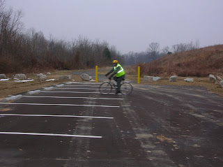
Dave rolling in the parking lot. Reflective gear works, doesn't it?
Once on the trail it became very reminiscent of areas found both around Shawnee and parts of the Levee Trail around the Mill Creek LG&E plant. It nicely followed the creek bolstered by some obvious juvenile plantings. As with portions of the Shawnee Riverwalk, I think it's too close to the creek and will suffer flooding issues, but either right-of-ways or ignorance keep the LL folks from learning from past mistakes.
New Bridge
More bridge. I guess it's been there long enough to collect falling leaves, so that puts the section in place mid to late Fall.
More reflectiveness
Nice view of path along creek
The initial portion of the path ended at a parking lot just of a small subdivision between 3rd St. Rd. and Greyling Rd. This sub happened to be just south of the church I attended in my youth, so I knew exactly where we were, and at this point we could've joined our route, but we saw more path, so, more exploring we did. This section was even lower than the previous and showed signs of mud run-off and some water pooling, not enough to make the trail unusable but bad enough for me to want to slap around the bozo who built the path. It came to a sudden dead end and we had a decision to make, turn around or find a way through the houses to our right. As a side note, the trail ended right next to an ugly ravine off the side of the creek and just down from railroad tracks. I think the next extension could be challenging.
We wound our way along a drainage easement so as to not scare the residents, the sight of 2 strange cyclist-dressed strangers in their back yards. I unfortunately didn't take a pic of the partial deer leg Dave found. Hmmm, good. Once back in the sub we were cold and ready for the return. We used Manslick and Iroquois again to bridge to the Woodlawn Sunergos. A cup and scone refreshed us for the last 6ish miles home where Dave carved off and headed home via Seneca Gds for a very satisfying, albeit early, 33-miler to start the day.


Comments
I spent all weekend with family visiting from out of town. I'm now quite motivated follow your inspiring lead.