The birthday was at hand, and it needed to be celebrated with an adventure. I usually sit around and grouse during the birthday times, but this year I decided to *do* something instead. For a fair piece of time, I strongly debated doing a road trip down to TX to Pondero's Ramble, but a weather forecast involving colder than expected temps, precip in TX, and more importantly, potential Sunday snow in KY conspired to put the kibosh on that idea. Next year, let's hope.
I prepared a gravel/mixed-terrain ramble of our in the DBNF around
S-Tree, an area I've visited via car but not by bike. I intentionally kept our route on the short side so we could go adventuring without too much pain and suffering. "Best laid plans", one might say. We began on top of the ridge where the campground sits, and warmed up in chilly 26F temps. We even had a little sun peek out, which helped warm us as we commenced our adventure.
I spied a clearing to the right of the road behind a gate, and we took a side trip to find an entire hillside with a haircut. Honestly, I don't really know why. It was sort of surreal to have vistas accessible when usually they remain hidden behind dense forests of trees.
Dave peeking out on the trudge back up the hill.
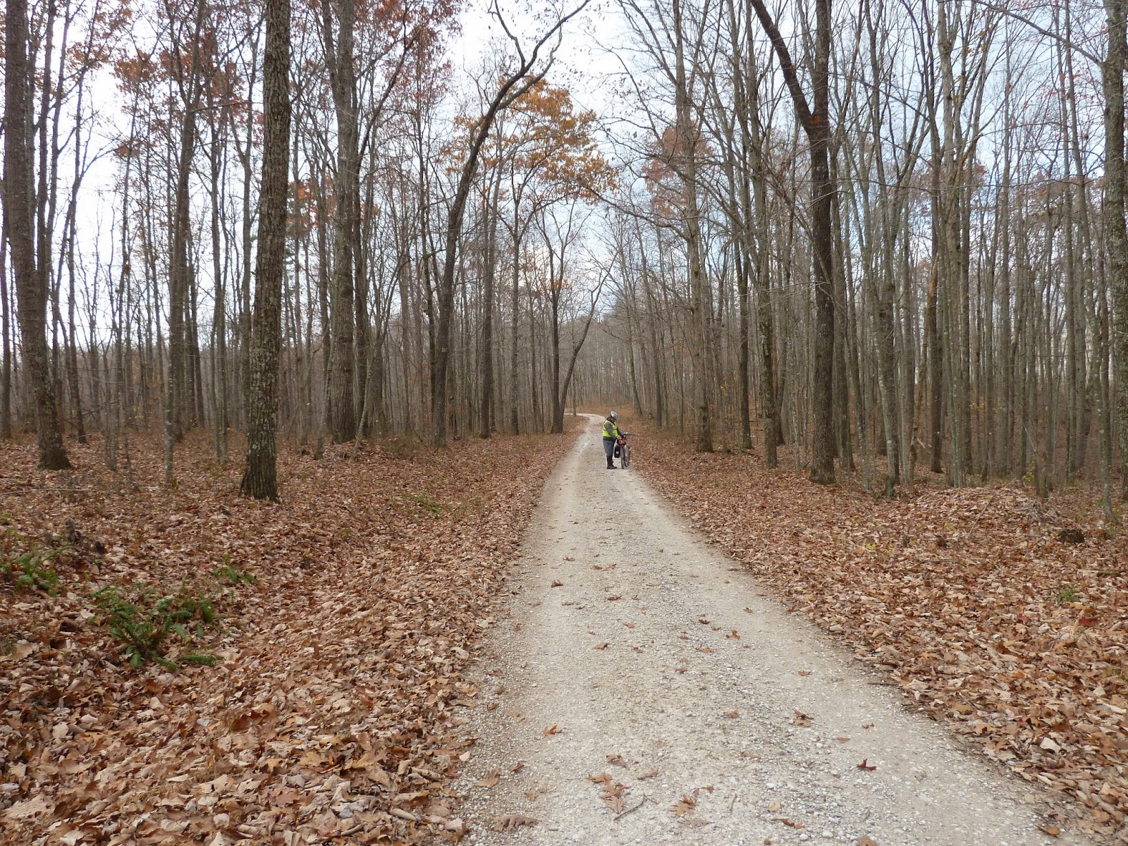
My favorite pic of the entire day. I just love this Fall scene.
Using our various gps units (we had 4 with us, my Garmin 60cx and back-up Edge500, which tends to collect better data and Dave's redundant Garmins), we turned left on either Tussey Hill or Renfro to find an unimproved, leaf-laden path. It followed a ridgeline, and gave us the benefit of plenty of draining and a good dry surface (foreshadowing). This was a really nice stretch, and felt just a little bit more rustic than the maintained gravel leading out of the campground.
After a plunge down the graveled hill, we found our one batch of pavement for the day, along 89, which is marked as a KY highway. What we found was a rather narrow non-lined road along the river. It felt much more like a small side road than a major thoroughfare through the area. Incredible, really. The Mukluk wasn't particularly fun on the pavement, and a creak was driving me a bit daft. Yet, it was a nice run for a bit, aside the dogs. Dave mostly dealt with the dogs.
Our turn was approaching ,but first we had to cross what, for me, was one of the strangest sights of the day, a wooden-topped bridge along a "highway". I mean, I've crossed tiny, little wooden bridges in far forgotten river bergs before, but not along such a thoroughfare. Just strange. It also meant that our turn back onto the dirt and gravel was imminent. Muy bien.
Notice the bike sign just past the bridge. I have to believe that a regular, organized festival ride comes through this area. I noticed, as well, on Strava that certain close roads have numerous trips. I can't imagine regular locals plying their trade.
Horse Lick Creek Rd. provided us a dirt/gravel combo that was pretty agreeable, following the contour of the creek path. We stopped a bit at the intersection of White Oak Branch Rd. to have a snack and prepare for the next batch of texture. We were even passed by our only vehicle of the day on non-paved roads. A friendly wave was traded and soon we were on our way, deeper up the creek run.
A forest service sign mostly in the middle of nowhere. We found a fair amount of signage for such a rural area. I didn't snap one, but this is also the path of the Sheltowee Trace, which is a multi-use path through much of DBNF.
At this point after a somewhat relaxed roll along the creek until we reached the point below where our track and the road both crossed the creek. You may be able to tell that, firstly, it was a pretty wide stretch with a reasonable flow, and more importantly, it was probably below freezing. We might have even seen a Private Property sign on the other side as well. It just didn't seem logical for our "road" to cross a good sized creek. We turned left on another path along the western side and made progress.
I could have/should have taken pics of all the mudholes we encountered. I mean, it seems like we passed hundreds of them. Often they were quite deep, and with the temps we didn't want to get too wet. Sometimes we could work our way around pretty easily, sometimes not so much. Rocks and mudholes. Lots of rocks and mudholes.
After some mudhogging.
This fork would portend an interesting turn of events, although we didn't know it at the time. We followed to the right along our track. At some point Dave had correctly divined that our track should be on the eastern side of the creek. Up to this point we had a usable path. Shortly after this fork, we found the scene below.
 |
| Sorry, out of focus. |
The path ended and crossed the creek at the first picture. I would estimate that the depth would be at least mid-thigh, and maybe even waist deep in the middle of an active run. Nope. We ventured upstream (second pic) and decided to cross there to minimize our distance. We both removed bottom layers to only cycling shorts and prepared to keep everything as dry as possible. Dave took 2 steps in and said, "No way!". Too cold, with swift water, a surface of unknown slickness and feasibility, and, remember, temps below freezing. Plan B.
We returned to our fork and decided to see what it could do for us in lieu of returning all the way back down the creek road. What we found was an unrideable, rock-strewn haul that went up for a good stretch. It wasn't fun.
After the initial crawl of .2 mile, things leveled out a bit and we were able to ride, on what kind of path I'm not sure. I didn't seem much horse or 4-wheeler damage, but it seemed to be too wide for a foot trail. Whatever it was, we took it.
After a rideable rocky portion, we again had to dismount and push, only this time up a steeper pitch that wasn't much fun. The interesting part, though, was found at the top, a rock bridge and rock house. The natural bridge in particular was a nice find; the paths around it suggest that we weren't the first Europeans to explore there. We didn't stay very long, and trudged the final 100yds straight up hill to the summit where we found remnants of a campfire. Again, we weren't first.


At this point, while Dave was climbing, I looked around a bit to try and discern where our path led. It wasn't all that apparent, and this was probably the first time of the trip where I felt a little freaky-outy. We were basically lost. Yes, we had gps units and could get back to our original creek path, but it was cold, the terrain challenging, and I imagined that moment when you are adventuring and suddenly fuck up and die. Fortunately, I found what looked to be a continuation of our path and we head on. One thing not photo'ed but noticed were a series of yellow painted intersection that earlier made us think this path did *something* productive. As long as we saw those, we had to go somewhere. At the top of a ridge our path gave us a 'T', and I chose to head right, towards our car. We then began a long, fun descent that was obviously returning to our creek.


After a boulder-strewn descent we found our creek again, only this time with a *MUCH* more passable portion. I went first and managed to cross the entire creek with some wettish feet, but certainly not soaked ones. Dave took a slightly different line than I- I think a little more upstream- only to find himself bogged down and dabbing. The water streamed ;) into his boot, and now we were really pretty damn wet and cold.
At the crossing we found an obvious "spot" with tracks, and followed them out to find an interesting (unphoto'ed) hillcrest with wood and evidence of several campfires. It surveyed the only meadow for miles. We took the opportunity to eat and for Dave to fish out his dry socks (smart work, there). We were back on track and ready to make more progress.


Honestly, at some point soon shit gets hazy. As you can see below, we were traveling in a bog, a partially frozen bog that was starting to wear a bit. Furthermore, for a bit we were "on track". We saw another creek crossing which I avoided, but in turn kept us on this "path" on the high side of the creek, the side we needed to be on as far as where our car was parked. It was not necessarily on the "road" though. We didn't really know what kind of "road" was on the other side, but that was where we were supposed to be. I was pretty insistent that we use our "road" and make progress as long as it let us. We rode through mudholes, around and over rocks, and through a bizarre creek-side path that almost had to be mowed. Or not. I don't know. It was weird 3-4 miles.
Nice ice layer. Didn't I mention that it was cold and that we were wet?
Dwelling. Edifice. Boondocks.
Green
That's our "road" on the other side of the creek. I seriously didn't want to cross through 3ft of flowing cold-as-shit water, and thusly was willing to put up with the "road" we took. Other than Dave almost breaking his face, it worked out.
We finally hit a little infrastructure in the guise of a tired, misplaced culvert. Certainly some fucking civilization must be at hand!!!! Shortly thereafter, well, after some more rocks and mudholes, we spied a fence gate and finally the junction to Raccoon Creek Rd. We had decided long ago that this adventure would have to have a detour given our time out and the failing light. Did I mention that the bikes were starting to freeze up?
These 2 following pics nicely sum up the differences I've personally noticed at S-Tree.
Two summers ago Patrick and I tried to bike tour through here. Due to a mechanical mishap and a case of cold feet, we drove through instead of biking, but at that time we had lush forests and trickles of water along the concrete crossings in DBNF. Instead, Dave and I traveled through on two wheels in below freezing temps with water that, for me, was too high to be comfortable when completely sodden and below freezing. I have a new respect for those Alaskan coast fatbiking guys. How do they do it?
Our day was almost complete. We did the best we cold with frozen, failing drivetrains and made slow, steady progress up Racoon Creek Rd. and its 2-mile climb. It was an intense, slow-motion way of ending our adventure. I didn't have to walk, Dave did, but I'm not sure we really traveled at different speeds. We just trudged up and made it happen in the failing light of day.
 |
| We marveled at the mountain top meadow several hours previous only to find this nasty scar of a road at the bottom. Not sure what the story is, but it doesn't look good. |
We did it. It was an adventure and we broke neither bone nor bike (as best as I know right now). As of the end of the ride I really didn't need that kind of punishment again, what, the mudholes, rocks, and freezing, wet temps.
I'm ready to go back.