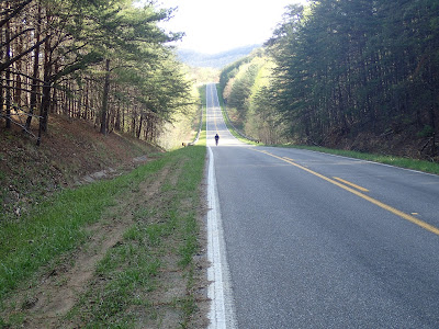
We had originally planned on leaving from Wildcat Adventure 4x4 Park. Instead we left from the Shell station on the route, where the folks were nice enough to let us stash the car. Immediately out of the parking lot we began climbing just to get the blood pumping. Shortly thereafter we found a fresh bear track. Uh. It as going to be "that" kind of trip, perhaps.
I used a variety of map sources and knew that after a short bit of labelled forestry road things would get interesting. Some maps had Falls City Rd going all the way through, others like the KY RASR map not. What we found was somewhat definitive, huge barriers blocking the road from what I assume were/are off-road killing machines. It was quite strange to open our 5-day trip with a strenuous hike-bike just a couple miles from our departure, but marshal on we did for some 3 miles until passing a cemetery which marked the beginning of gravel and the end of the march. I won't mention the poison ivy or spectacular backwards crash which almost ripped open my testicular sack. Yay!
Barriers meaning business
More barriers not long down the trail. The two red lines, I believe, marked the 4-wheeler trail. We saw plenty of Sheltowee markers too.
Fun sandstone formations which we should have ridden, but just a few miles in we were feeling conservative.
Cemetery marking the end of the not-trail section. Note that it is miles from anything. The depopulated nature of the DBNF region is, to me the history major, fascinating. Huge populations of folks have been buried and the land is returning to forest in many places.
We faced a mix of gravel and pavement for the next several miles, some of which was quite fun, such as along 1956. The newer high-volume road 80 runs parallel, so 1956 is left to the neighbors with little traffic. We crossed 80 and had a couple more miles of pavement until hitting more gravel at around mile. The next several miles presented us with classic DBNF gravel with plenty of creek valley dives to keep things interesting. The heat was taking its toll as well, so we stopped when we needed and didn't stress over pace. As always, it's provides blissful riding.
My camera starting acting up at this bridge crossing, but I like the shot anyway. I have a cleaner phone version I posted on FB. I mean, it's a wooden plank bridge at the bottom of a huge descent in the middle of a forest. What could be better?
Creek crossings, especially cool water crossings in summer, are a delight. This one was easily navegable and a highlight of my day.
Patrick on far end.
Forest
A most interesting experience is not documented in the pics, but needs a bit of description. At the junction of The Narrows and Rooks Rd (depending on maps-37.069743, -84.266169) we passed a series of house/shacks/dwellings and passed our turn as well. The dwellings had water tanks, outhouses, and appeared to be pretty well maintained for shacks, but seemed completely deserted. A ghost town. We doubled back to find the opening to Rooks Rd. a bombing half-mile descent which we tried to take wide open. At some point, too, we stopped for a noodles-n-protein lunch. It did the trip. Oh, and we walked. We walked a lot. My fitness level was just not prepared for the loaded, gravel climbing. None-the-less, it was a great run through the forest.
Loaded Jones at the lunch stop. More comments on gear later, but suffice that the Jones is a great mount.
Remnants of lunch. Yes, we hauled out our trash.
We, in fact, walked.
At the end of Rooks Rd Patrick asked a nice lady for water (which she obliged) and I lay down in the shade along the road. Shortly after a gentleman in a SUV with a couple kids in tow turned and stopped. Hmm, what could happen here? He then asked if everything was alright and if we needed anything. Talk about KY hospitality! We turned onto the more significant 192 and headed towards Bee Rock, again stopping for a bit for a snack and taking our time until, again,bombing down the descent into the Rockcastle River valley and turning into Bee Rock Campground.
Bee Rock is a nice campground with secluded, wooded spots and access to latrines and more importantly water. We set up camp, hung out, visited the bridge, ate, visited the bridge, hung out. Strangely, Patrick and I are both morning people, so when you leave camp at 7ish and have 30 tough miles on the plate, you still finish you day sort of early. Our second trip to the bridge was a surprise with dark clouds to the north. The forecast was rather dry, but Patrick fretted as to set up the tarp or not; we were bivying with our bikepack setups. Eventually he did and I did as well.
Bee Rock CCC bridge.
Angles
Sunset over Rockcastle River
Those northern skies aren't all that sunny.


2 comments:
Nice. I wish I could have made it.
The "ghost town" you mention is visible-ish in aerial-view:
https://goo.gl/maps/EXADj
It's refreshing to experience the friendliness of people when we are traveling on our bikes.
Post a Comment