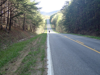
While the sunshine and pleasant temps helped reduce the layers needed (and my cold weather complaints), I encountered a new variable very early on, the northerly wind which brought the amazing December temps. I hoped and assumed that it would be a side wind at worst, but with my general SE direction I faced a 3/4 headwind very early on; it became the theme of the ride.
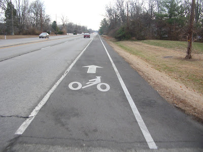
I did my usual route out of town via Taylorsville Rd., which now sports a "bike lane". I rode to the right of it where there was less glass, rocks, plastic, screws, metal shards, etc etc. Once I cleared J'Town I used Rehl, S. Pope Lick and English Station to deliver me to the "country".
Manse playing peekaboo.
Floyd's Fork Creek valley
I took the pic below while descending what should have been a nice hill to deliver me to 25mph or so. Instead I found myself pedaling to maintain 15mph, downhill. The flags indicate a SSE wind direction, which was highly, highly unfortunate. That's the direction I had to turn, directly into the teeth.
I detoured briefly off 148 to investigate Clark Station Rd., which obviously followed the railroad. It was a nice diversion.
I love this pic, the spookiness of the gnarled, low-hanging trees and grizzled fence and gate.
Clark Station, I presume, from days gone past.
After leaving Clark Station I faced the drag up 148. This is a route I took often when my parents owned a home in Finchville, Ky, which was 27m from my house. I remember making it in about 1.40 (16mph). This day I made it barely under 2hr. I looked at some data and found that I was riding during the prime windy time of that day, and it happened to be either in my face or on my front shoulder for the first 32 miles of the ride. I wanted very badly to turn around and ride the windy wave back home, but, nope, that wasn't the plan.
This building is unremarkable except that I had to hide behind it for 5min or so to get away from the wind.
The route shifted NE up 44 and 714, and with that some wind support and some dippier climbing. This ridge top portion lasted 5 miles and gave me some respite. I did encounter an interesting menagerie of homes along this stretch.
The post-modern geodesic dome was on the right of the road.
The crumpled remains of glories past were on the opposite side of the road.
I began my third portion of the ride at mile 37 when I turned right onto Scott Pike. These were new roads deep into the more scraggly portions of Shelby and Anderson Counties. I found roads that dipped into creek beds and along the crags under the hills. Road surfaces were full of rock and cinders from previous snows. I was very glad to be riding the 35c 650b Soma tires.
Goats at the turn of a steep section on Scott Pike
I walked this section; I just needed to.
Ditto Rd. was much like Scott except a bit spookier and more remote.
At the turn from 1472 onto Cox Ln. I came across this delightful church and graveyard. It provided a nice place for a snack, swig and snaps (sorry, cheesy alliteration)
Cox Ln turned into Avenstroke at the tracks. After a climb out of the valley the road ran ridgetops for a while and provided some fantastic views of the surrounding terrain. Maps indicate a creek running to my left, one which must have carved out the surrounding valley. I may have been this way before, but it didn't matter. I felt much better during this stretch, but my goal of riding a good tempo for this ride was long gone. It was pedaling squares and taking pics.
The lump centered behind the fence post is, in fact, a trash dump. Way to wreck the great visual lines of this vista!
I made the decision at some point in this area that I was finished for the day. My plans were to reach Frankfort, cross the KY river and curl south a bit and back out of the river valley, arriving at the eastern interstate stop where the family could pick me up. That plan would include a total of 66 miles or so. At some point I had had enough. My legs were honestly tired. I'm sure I could have reached the 66, but I had passed my 3k goal and I wanted to end the ride in a non-negative, miserable state. We were going to a friends' house. Why arrive wasted?
I turned north at Old Lawrenceburg Rd. and crossed I-64 without difficulty. I knew of both a Starbucks and a Panera and stopped at the Panera, where I had a sandwich and a few more snacks. I enjoyed the hour or so of reading about the UK beatdown of UL (always nice- Go Cats!!!) and even read a bit of a book I had brought for this contingency. Ol' Mother Nature had defeated me on this day, but it was still 57 miles in 60F temps on the last day of '10. Not bad.


4 comments:
Nice to see the Bleriot again. I'll bet you enjoyed the excellent conditions...
I always enjoy the combination of your pics and comments. I love the look of drying empty houses. Kentucky has lots of them, but you can find them lots of other places. (There's a great one heading over to the Jersey Shore barrier islands.) Enjoy the rest of your day!
Is that bike lane on Taylorsville for 'bents?
Doesn't sound like defeat to me. You accomplished what you set out to do. Looks like a great ride, despite the winds. I was so glad to turn away from the wind that day, and I put in fewer miles than you did.
The photos look great ... there sure is some beautiful rolling terrain down that way.
Post a Comment